The Preselis and Gors Fawr, Wales

Horses and sheep roam free in the Preselis.

Looking north to the Preselis Mountains, close to the source of the Stonehenge bluestones, 250 miles away.  The Nevern Valley is just beyond these mountains to the north, which is where XRF testing of a quarry indicated the closest elemental match to the Stonehenge bluestones.

View to the southwest of Gors Fawr Stone Circle, south of the Preseli Mountains.  A bit over 72' in diameter, the ring is made up of sixteen small (2'-3' high) standing stones, including one bluestone, which rise in height toward the south.  Not far to the north are two outliers, each about six feet tall.  I haven't found any good dates yet for when it may have been built, but its likely to have been in the Neolithic or early Bronze Age.

Roughly in the middle of the stone circle

View to the west


Looking north to the Preselis and the two outliers


One of the two outliers, this is known as the Dreaming Stone.  Whether it was shaped like a chair for the purpose of sitting and daydreaming thousands of years ago, I know not.  But that's what its used for now.


View of the two outliers, Dreaming Stone in the foreground, looking to the southwest.


The Stonehenge Bluestone Quarry, Nevern Valley, Wales

Michael Parker Pearson, in blue, describing the site to guests.  They are standing on what appears to be a stone-circle reject.  XRF analysis on the stones at this quarry are the closest match to the bluestones at Stonehenge.  Although close to the Preseli Mountains, the location is in the Nevern River Valley.


The area to the left of the stone, where the shovel is, is where I got to dig for two days.  So far, besides quarried rubble, flint flakes and hammerstones have been found here.


When I met Michael Parker Pearson, he found it quite funny that I just happened to be an archaeology student from California who, more or less, stumbled into this site.  He asked me if I wanted to jump in and dig, and I said I'd love to but I have to take my rental car back to Fishguard and get on the ferry to Ireland.  Right away I thought to myself, "What the hell are you saying, girl?"  I loitered around for about twenty more minutes, then asked one of the archaeologists, Duncan, if he'd like a break.  He seemed eager for one.  Let me tell you, leather biker boots are NOT ideal excavating shoes. 
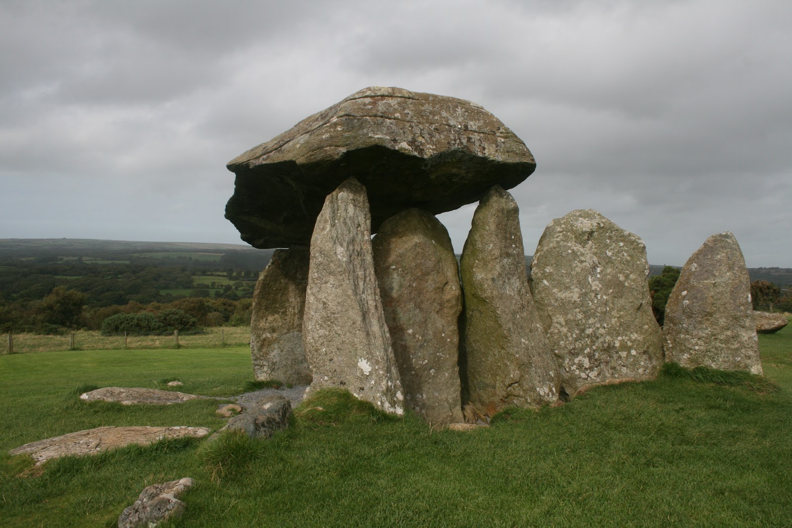
But there I was, touching a blue stone possibly meant for a henge.  Parker Pearson thinks that perhaps the builders of Stonehenge didn't come to this quarry themselves, but took the stones from an existing, already-ancient stone circle.  Some of the earliest people in the British Isles are from this valley, and they built many stone circles.  Its possible, then, that for whatever reason, the stones from this quarry, meant for another henge long before, were removed and incorporated into a wider-ranging ancestral henge on the Salisbury Plain - Stonehenge. 
The work that Parker Pearson and his colleagues are doing now is sourcing materials from Stonehenge.  Alasdair Pike, for example, is sourcing the gold found there.  XRF analysis and other new technological methods allow archaeologists to find the origins of materials in a way that has never been possible before, so this work is truly groundbreaking. 
The more time spent analyzing Stonehenge, the more it seems that the builders were making a concerted effort to unify different peoples of the British Isles, as there are already ties to Scotland, Wales, and possibly the continent.  It will be interesting to see where these other materials are coming from.  We're at a place in history where many things will be made clear to us about Stonehenge that have never been before.

View of profile and quarried rock with hammerstone.


Amongst the trees is the Afon (River) Brynberian.  It is highly unlikely that the stones were transported over water.  Underneath the bluestone, however, are long narrow stones which may have been used as a sort of skid road.  Yes, the transportation issue is still quite a mystery.


My groupie shot.  At the end of the workday I was invited to dinner, with the other archaeologists and field school students.  They were all staying in an enormous house in Cwm Gwaun (Gwaun Valley), where I had been two nights before and had met Kate Welham and Alasdair Pike, the archaeologists who invited me to check out the site in the first place.  We had been at Dyffryn Arms, famous in the area for its intact traditional style (it has stayed in the family and hasn't changed much in 140 years), and its owner, Bessie Davies, an eighty-year-old native-Welsh-speaking legend in her own time.  She does what pub owners and landladys used to do in the past, come out and sit with customers, strike up a conversation, and act like a host.  Everyone in Pembrokeshire knows about Bessie, and her style is unfortunately fading out.

After having dinner with the archaeologists, we all went back to Bessie's pub for pints.  Mike's wife and her sister joined us there, as they had grown up spending summers in Cwm Gwaun and had known Bessie all their lives.  Afterward we went back to the house...some of us stayed up a little longer.  I must admit, it was kind of cool to be standing on the fronth porch with Michael Parker Pearson, talking about his early experiences as a student of Ian Hodder and the post-processual theoretical movement, at 12:30am with a glass of Mount Gay Barbados rum. 
The next morning, they were one archaeologist short so I got to spend the whole day digging again.  It was serious, fast troweling through a gunky layer of gray-black mud to the soil which would have been the surface that these Neolithic rhyolite miners would have been standing on.  I found a hammerstone, small piece of flint, and some sort of pit about a meter in diameter.  In late afternoon Mike had me finish the area I was working, sweep down the surface and make it look nice for mapping and photos before he "let me go" to return my car to Fishguard and catch the ferry to Ireland.  I realized at that point that five weeks was definitely not enough time for the vacation I wanted to be on.

Pentre Ifan Burial Chamber, Wales.


Road to Llanon, Wales, view of the Irish Sea

After my visit to Castell Henllys I befriended the park's historian, Roger, and the next day he took me to a couple incredible ancient sites nearby.  Pentre Ifan, which dates to ca 3500 BC, is a burial chamber marked by a monument which appears to be somewhat typical of Wales and Cornwall and likely beyond.  It consists of an elliptical-shaped stone with a flat bottom placed atop pointed uprights in such a precise fashion that makes it appear almost delicate.  It is located on a slope and faces due north, towards the Nevern Valley, pointing directly toward another similar stone monument which was built sometime afterwards.

We walked through the woods to get to Pentre Ifan.  On the way we encountered several moss-covered remains of Iron Age structures like this.      


This stone house isn't that old, but was fun to wander around.  We could see the fireplace, chimney, the two rooms, the winding drive, the stone steps to the house, low stone walls, the cleared garden area, etc.  It was easy to imagine a family here, nearly within view of Pentre Ifan, in this little isolated woodland.    
My first view of Pentre Ifan

 
The Nevern Valley is visible in the distance.  Standing stones fanned out in the back, although only a few are left.  I was told that the stone placed directly beneath the capstone, in the middle, was the last stone placed there, indicating the closure of the funerary rites that took place at this burial chamber over time.  Its date suggests pre-Celtic people built Petre Ifan, but like many ancient monuments, Celts likely incorporated it into their ceremonial life.  Below is antiquated speculation: 
"The region, the little valley on whose side stands the Pentre Ifan cromlech, the finest in Britain, is believed to have been a favourite place with the ancient Drulds. And in the oak groves that still exist there, tradition says there was once a flourishing school for neophytes, and that the cromlech instead of being a place for internments or sacrifices was in those days completely enclosed, forming like other cromlechs a darkened chamber in which novices when initiated were placed for a certain number of days....the interior being called the womb or court of Ceridwen. "
WY Evans, The Fairy Faith in Celtic Countries, 1911


Roger takes groups up here all throughout the summer but this could never be old news to him, he still enjoys every moment.

Carn Ingli in the background, which is Welsh for Angel Mountain.  Some say the capstone was shaped to reflect Carn Ingli, which is supposedly a sacred site.  One of the women I had met in Hays Castle Cross a couple days earlier had sternly warned me about wandering around Carn Ingli on my own, and to have the utmost respect should I decide to go there.  I didn't go this trip.  But I will next time.  Carn Ingli is due west, and to the northwest is a nice view of the Irish Sea.

My tour guide and me.


Not far away are these two holes, which one can put both hands in easily, almost up to the elbow.  So far I've heard no explanation for this.  On top of the rock are some shallow cupuoles as well.

Castell Henllys, Pembrokeshire, Wales

Castell Henllys, a reconstructed Iron Age Celtic hill fort.  This exact location was excavated by archaeologists several years ago, and the replica structures were built on top of the existing foundations.  The gateway, which you see above, was reconstructed according to the posthole pattern in this wavy formation.
A fire is burning here, to demonstrate the theory that these rooftops did not contain holes in the top for smoke to escape.  They had first built thatch roofs with holes in the top in the reconstructions, and found that the fire was more difficult to control.  The roofs, built with reeds, are very breathable.  When you walk in, the smoke isn't bothersome at all.


Examples of the interior

I had to play a little!

Roger, the historian and site interpreter demonstrating a lathe.

The Wicker Man!  He's hiding in the granary.

Another view of the huts


The top of one of the doorways - you can see the hollow reeds used as thatch material.

Not a bad view.

Close up of the largest hut.  I liked it here...it was a cool setup, I think, to take an exisiting archaeological site and use it as the template for a reconstructed site, which really brings to life something that would be hard for most people to imagine.  The stone structures, the wall, the ditch and mound surrounding the hill fort, and other archaeological features that remain have been left intact.

Tintagel - the legendary birthplace of King Arthur.


Tintagel Head


The coast just southwest of Tintagel.  I've been wanting to travel to Tintagel since I was a teenager, reading about the Arthurian legends.  The legends are as numerous and as varied as one could imagine, but the basic story is that Uther Pendragon, a Romano-British king, wanted Igraine, the wife of Gorlois, the Duke of Cornwall.  Uther asked Merlin to help him figure out a way to spend the night with her in Tintagel, where she lived. Merlin offered to cast a spell to make Uther look like Gorlois for one night, in exchange for the child that would be conceived.  Merlin had apparently had visions of Arthur's birth and success as a great king, so he manipulated the situation to make it happen.  The night that Uther visited Igraine, Gorlois was killed in battle.  After the birth of Arthur, Uther and Igraine married.  It's a possibility that a conection may exist - Tintagel head is covered with structural remains and artifacts dating to the 5th and 6th century, the time most people believe King Arthur was alive.


The view to the castle remains.  What you see was built by Richard, the Duke of Cornwall, in the 1200s.  Richard was a contemporary of Geoffrey of Monmouth, who spun the tales of Arthur that we know today.  Although Geoffrey of Monmouth is not a reliable historical source, he had everyone convinced that Tintagel was the birthplace of Arthur and the seat of the ancient Dukes of Cornwall.  With that in mind, Richard built this grand structure mostly out of a romantic desire to be assoicated with the mystical Arthurian legends.


Photos showing both openings from the middle of a crazy cave that cuts beneath Tintagel Head.  There must have been tons of things that went on down here.


The courtyard of Earl Richard's castle - ca 1200s.


Doorway going from Richard's courtyard toward the top of the headland.  The masonry all over Tintagel is really cool - the rock is primarily shale, a flat, thin stone, making for some interesting structural designs.
 
View northeast to Merlin's Cave.  The photos from the interior of a cave shown earlier are not from Merlin's Cave, but from one far beneath where I am standing when I took this shot.


Here you can see traces of 5th century buildings and walls.  I can see how the Tintagel headland would be great defensible space, but the weather is very violently windy and there are precipices everywhere.  You could get blown off this thing.  Can't imagine it would have been a very comfortable place to live.  However, there are more pieces of imported Mediterranean pottery that have been found here than in the rest of Britain and Ireland combined.  Obviously this area does not function well as a port, so archaeologists believe a wealthy and/or powerful group of folks must have lived here in the fifth century.


Aaahhhhh.


The view from the head toward the mainland.  You can see Richard's castle in the background built on a huge rock; in the foreground are the 5th/6th century remains.  The headland and the mainland were separated by a small isthmus when people lived here 1500 years ago.  By Richard's time it had been washed away, so he built a bridge between the two.


More of the early remains


A tunnel, which was built using metal tools, at an unknown date.  No one knows what it was used for.  Cold storage, drainage...?  Surprisingly, there is a fresh water well at the top of Tintagel head, a huge desolate rock, about 20 meters from this tunnel.


Sitting in the tunnel


View from the head to the southwest


Absolutely insane wind action.


More views from the head to Richard's castle.


This flint blade dates to be from the Mesolithic, around 6000 years ago.  It was recently found on Tintagel head.  
Graves in the cemetery at the church on the mainland just inland from Tintagel, and a Roman mile marker inside the church.  Below is a Medieval cider press a few miles away in Slaughterbridge, which is said to be the location of the last battle of Arthur, where his son Mordred killed him.